

The SORA 2.5 Evolution: A New Era for Beyond Visual Line of Sight (BVLOS) in Canada
- krdroneworks
- Apr 4
- 3 min read
By: Colonel (ret) Bernie Derbach, KR Droneworks Academy, 4 April 26
(Inspired by a article from Paul van der Wal -UAS Consultant at Drone Flight Company, 31 March 26

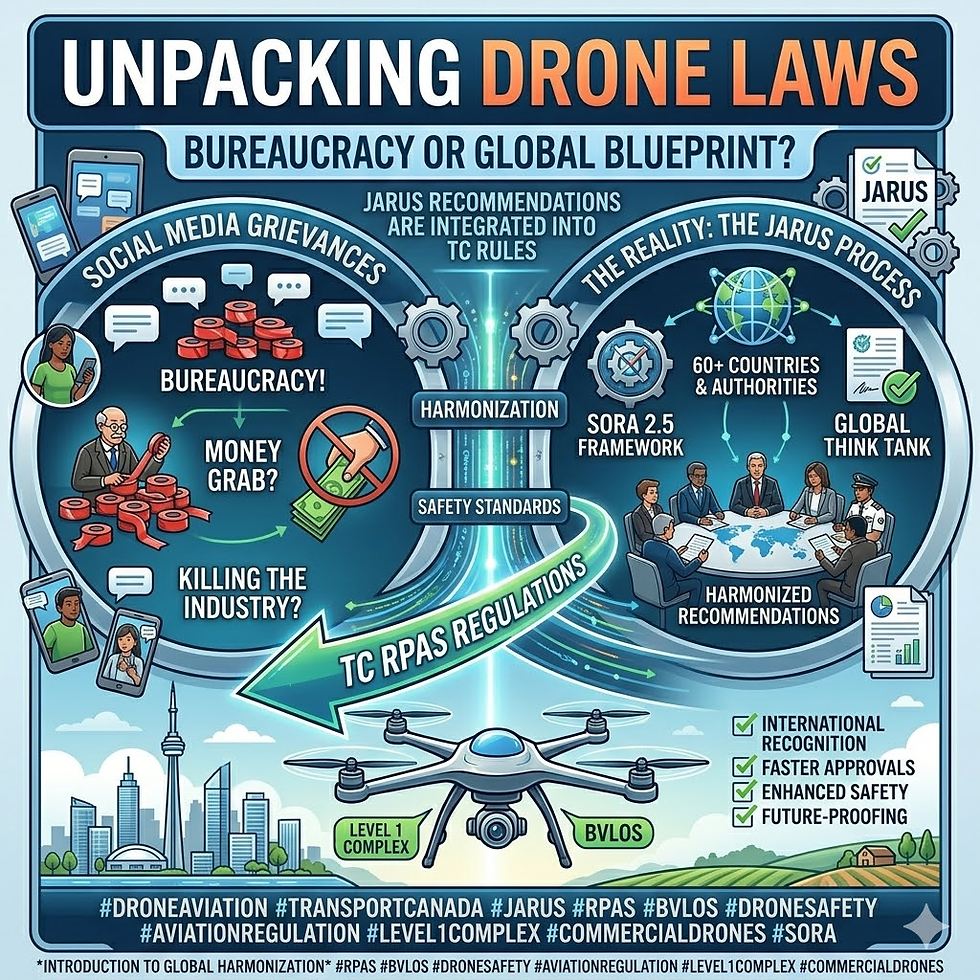
The landscape of Canadian drone operations has undergone its most significant transformation since 2019. As of April 2026, Transport Canada (TC) has officially transitioned to the JARUS SORA 2.5 (Specific Operations Risk Assessment) methodology.
For the professional drone community, this isn't just a nomenclature change; it is a fundamental shift in how we justify, document, and execute missions. Whether you are conducting low-risk missions under the newly "unlocked" Level 1 Complex (L1C) framework or managing high-risk urban BVLOS, the rules of the game have evolved.
1. SORA 2.0 vs. 2.5: What Actually Changed?
The transition from SORA 2.0 to 2.5 represents the "professionalization" of drone safety. While 2.0 allowed for more qualitative descriptions, SORA 2.5 demands quantitative proof.
From ConOps to DOI: The "Concept of Operations" (ConOps) is now replaced by Detailed Operational Information (DOI). You no longer just describe your mission; you document it with structural consistency, covering everything from "impact energy" to technical "robustness.
The Critical Area Concept: Ground risk is no longer just about "where" you fly; it’s about what happens if you fall. SORA 2.5 places a heavy emphasis on the drone’s mass, speed, and kinetic energy to determine the size of the "critical area" affected during a failure.
Robustness Levels: If you want to fly in complex environments (like urban centers), you must now prove the robustness of your mitigations through procedures, training, and Design Verification Reports (DVRs).
2. The Level 1 Complex (L1C) "Unlock"
The highlight of the April 2026 update is the Level 1 Complex (L1C) regulatory framework. This is a game-changer for low-risk BVLOS missions. Under L1C, if your mission fits within "pre-calculated" safety boxes, you no longer need an individual SFOC. This is a prescriptive framework: follow the rules, and the mission is authorized.
The L1C Flight Envelope:
Airspace: Uncontrolled (Class G) only.
Altitude: Max 400 feet (122 m) AGL.
Proximity: Minimum 5 NM (9.3 km) from the center of any CFS/WAS aerodrome.
Pilot: Must hold a Pilot Certificate – Level 1 Complex Operations.
Organization: Must operate under an RPAS Operator Certificate (RPOC) with an integrated Safety Management System (SMS).
3. Ground Risk Reimagined: The "1 km Rule"
For L1C operators, SORA 2.5’s complex math has been simplified into a Static Standoff Distance. The variable "1:1 Ground Risk Buffer" used in pilot planning has been replaced by requirements based on population density:
Mission Category | Density Definition | The Standoff Rule | Hardware Requirement |
Unpopulated | $< 5$ people/$km^2$ | Stay $\geq$ 1 km away from any Populated Area. | Standard 922.08 Declaration |
Sparsely Populated | 5–25 people/$km^2$ | May fly within 1 km or directly over. | Standard 922.07 (Pre-Validated) |
Populated | $> 25$ people/$km^2$ | Requires a Full SORA 2.5 SFOC. | Technical DVR/High Robustness |
4. High-Risk & High-Complexity BVLOS
If your mission goes beyond 400 feet, enters controlled airspace, or occurs over populated areas, you are moving into the Specific Category where a full SORA 2.5 SFOC is mandatory.
In these scenarios:
Design Verification Reports (DVRs): These are strategically vital. Manufacturers must provide proof that the RPA can meet high robustness levels (M2) to mitigate ground risk in cities.
Air Risk (ARC): While the logic remains similar to SORA 2.0, the level of justification for your tactical mitigations (like DAA systems) must be significantly more rigorous.
M1A/B/C Mitigations: You must now explicitly categorize how you reduce ground exposure (e.g., M1A for sheltering, M1B for operational limits).
5. Updates for Your Mission Flight Plan
To stay compliant with the 2026 standards, your internal documentation (like our framework at KR Droneworks) must be updated:
Rename Sections: Change "Concept of Operations" to "Detailed Operational Information (DOI)."
Define Volumes: Clearly map your Flight Geography, Contingency Volume, and Emergency Buffer.
Density Claim: Verify population data using the NRC Drone Site Selection Tool or Statistics Canada.
Hardware Validation: Ensure the drone's Safety Assurance matches the mission (922.08 vs 922.07).
Qualitative Hazards: Your Site Survey must now include a qualitative hazard assessment (power lines, terrain, birds) as part of your SMS oversight.
Summary of the 2026 Framework
The transition to SORA 2.5 moves the burden of risk calculation away from the pilot and onto the manufacturer and the regulatory framework. For low-risk L1C missions, your role is to verify the "boxes"—if you are 1 km from people in Class G airspace with a declared drone, the sky is yours. For high-complexity missions, be prepared to provide deep, structured, and demonstrable safety proof.
References & Essential Links
Regulatory Authorities:
Planning & Guidance:


Comments