


The Navigation Trust Gap: Why Modern GNSS Spoofing is More Than Just "Signal Loss
By: Colonel (ret) Bernie Derbach, KR Droneworks Academy, 27 May 26
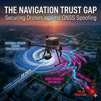
For years, the gold standard for drone defense was simple: break the link. If you could jam the control frequency or block the incoming GNSS (Global Navigation Satellite System) signals, the drone would typically default to a "fail-safe" protocol—usually hovering in place or initiating an automated Return-to-Home (RTH) sequence.
However, the threat landscape has shifted. Modern adversaries have moved beyond brute-force jamming and turned toward sophisticated spoofing. This tactical shift targets something far more fundamental than a connection: it attacks the drone’s trust in its own physical position.
When a UAV accepts false positioning or timing data as valid, the impact propagates through the entire flight logic. Safeguarding modern operations requires moving past "signal loss" strategies and addressing navigation trust, sensor fusion, and fallback autonomy.
The "DR-GNSS" Connection: How Drones Actually Navigate
To understand why spoofing is so effective, we have to look at how high-end drones calculate where they are. They don't just use GPS; they use a combination of GNSS and Dead Reckoning (DR).
GNSS (The Absolute Reference): Provides the "big picture" coordinates (Latitude, Longitude, Altitude) via satellites.
Dead Reckoning (The Internal Math): Uses internal Inertial Measurement Units (IMUs)—accelerometers and gyroscopes—to track movement based on speed and direction.
In modern drones, these two are merged via Sensor Fusion (often an Extended Kalman Filter). The GNSS corrects the natural "drift" of the internal sensors, while the internal sensors fill the gaps when satellite signals are weak.
Spoofing exploits this relationship. Instead of blocking the signal, the attacker feeds the drone a "mathematical lie"—simulated satellite data that perfectly mimics the movement the internal sensors are reporting, but slowly pulls the drone off-course.
The Failure Cascade: How Spoofing Disrupts Flight Logic
GNSS spoofing doesn't broadcast an error; it broadcasts a fake reality. Because the drone "trusts" these coordinates, the failure cascades through the system:
Position Error & Route Deviation: The drone believes it is on its flight path, but it is physically being steered into restricted airspace or toward a hazard.
Abnormal Return-to-Home (RTH): If a pilot realizes something is wrong and hits "Home," the drone uses its spoofed home coordinate. This can cause the drone to fly directly to the attacker’s location instead of the pilot's.
Hover Instability: During precise tasks like infrastructure inspection, even a slight "drift" injected by a spoofer causes the drone to over-correct, leading to erratic lurches and potential collisions.
Mission-Safety Risk: The drone becomes a "rogue" asset. It isn't lost; it is actively following a false mission directed by an external entity.
How to Protect Your Drone Operations
Defending against navigation attacks requires shifting the security paradigm from peripheral defense to internal resilience.
1. Hardening the Hardware
Multi-Constellation Receivers: Use systems that pull from GPS, Galileo, GLONASS, and BeiDou simultaneously. It is significantly harder for an attacker to spoof four different satellite networks at once.
Anti-Spoofing Antennas (CRPA): Use antennas that can "ignore" signals coming from the ground (where spoofers are located) and only listen to signals coming from the sky.
2. Intelligent Sensor Fusion
Flight controllers should be programmed with "Innovation Bound Checks." If the GNSS data suddenly contradicts the IMU data (e.g., the satellites say the drone is moving at 50km/h but the accelerometers feel no movement), the system should immediately flag the GNSS as "untrusted."
3. Non-GNSS Navigation (The Ultimate Fail-Safe)
The best way to survive a GNSS attack is to not need GNSS at all.
Optical Flow: Using cameras to track ground features and determine speed/position.
LiDAR SLAM: Mapping the 3D environment in real-time to navigate based on physical obstacles rather than coordinates.
Visual Odometry: Using computer vision to "see" where the drone has been and navigate back purely by sight.
4. Dynamic Fallback Logic
Operators should implement a "Zero-Trust" navigation protocol. If a discrepancy is detected:
Isolate: Cut off the GNSS stream immediately.
Verify: Revert to purely internal Dead Reckoning or Vision-based flight.
Execute: Instead of a long-distance RTH, initiate an immediate vertical landing or a "backtrack" using only internal sensors.
Conclusion
As we move toward more autonomous skies, the definition of a "secure" flight has changed. We must stop worrying only about whether the drone is connected, and start worrying about whether the drone is being lied to. By integrating robust sensor validation and alternative navigation methods, we can bridge the "trust gap" and ensure that drone operations remain safe, even in contested environments.
References
Global Navigation Satellite Systems (GNSS) Vulnerabilities and Security. (2025). Journal of Aerospace Technology.
Sensor Fusion and Kalman Filtering in Autonomous UAVs. (2024). Robotics and Autonomous Systems Review.
The Rise of Commercial Spoofing: Threats to Low-Altitude Airspace. (2026). Defense Tech Journal.


Comments